Symphony – a tool for ecosystem-based marine spatial planning
Symphony calculates how pressures from human activities in the ocean affects nature values in each location in the Swedish sea. The method and associated application were developed by SwAM and are primarily used for Marine Spatial Planning.

What is Symphony?
Symphony is a method developed by the Swedish Agency for Marine and Water Management (SwAM), to quantitatively weigh ecosystems and environmental pressures. With Symphony, the cumulative environmental impact from different marine spatial planning (MSP) options can be objectively compared. Cumulative environmental impact refers to the combined pressure from different kinds of human activities on the marine ecosystems. This cumulative impact indicates the consequences for the environment. In this way, marine spatial plans can be developed with an ecosystem approach.
Symphony has been used in the Swedish national marine spatial planning from autumn 2017 during the planning-, dialogue-, and evaluation phases. This scientific method is transparent, easy to understand, and easy to interpret. Symphony is also the name of the associated application that SwAM has developed to perform these calculations.
Why is Symphony needed?
When a proposal for a marine spatial plan is developed, a concrete method to determine the cumulative environmental impact in the ocean is needed. With that knowledge, it is possible to plan with an ecosystem approach in mind, to avoid high cumulative environmental impacts in sensitive areas and compare different planning alternatives. This information should also be included in the Environmental Impact Assessments, developed for each marine spatial plan. To address these needs, SwAM developed Symphony. The analyses made with Symphony is used during planning, to compare different planning alternatives, to communicate with stakeholders, and to evaluate the marine spatial plans.
How Symphony works
Symphony calculates how pressures from human activities in the ocean impacts nature values (ecosystem components) in each location in the Swedish sea, divided in a grid with cells of 250 x 250 m. The results are visualised in heat maps, which makes it easy to identify areas with high and low environmental impact.
The method can be summarized in five steps:
1. Nature values
Distribution maps of nature values (ecosystem components) in the Swedish sea has been developed. These are based on existing data and compiled by experts. Symphony includes 32 different ecosystem components, for example cod, fish spawning areas and, mussel reefs (se Figure 1).
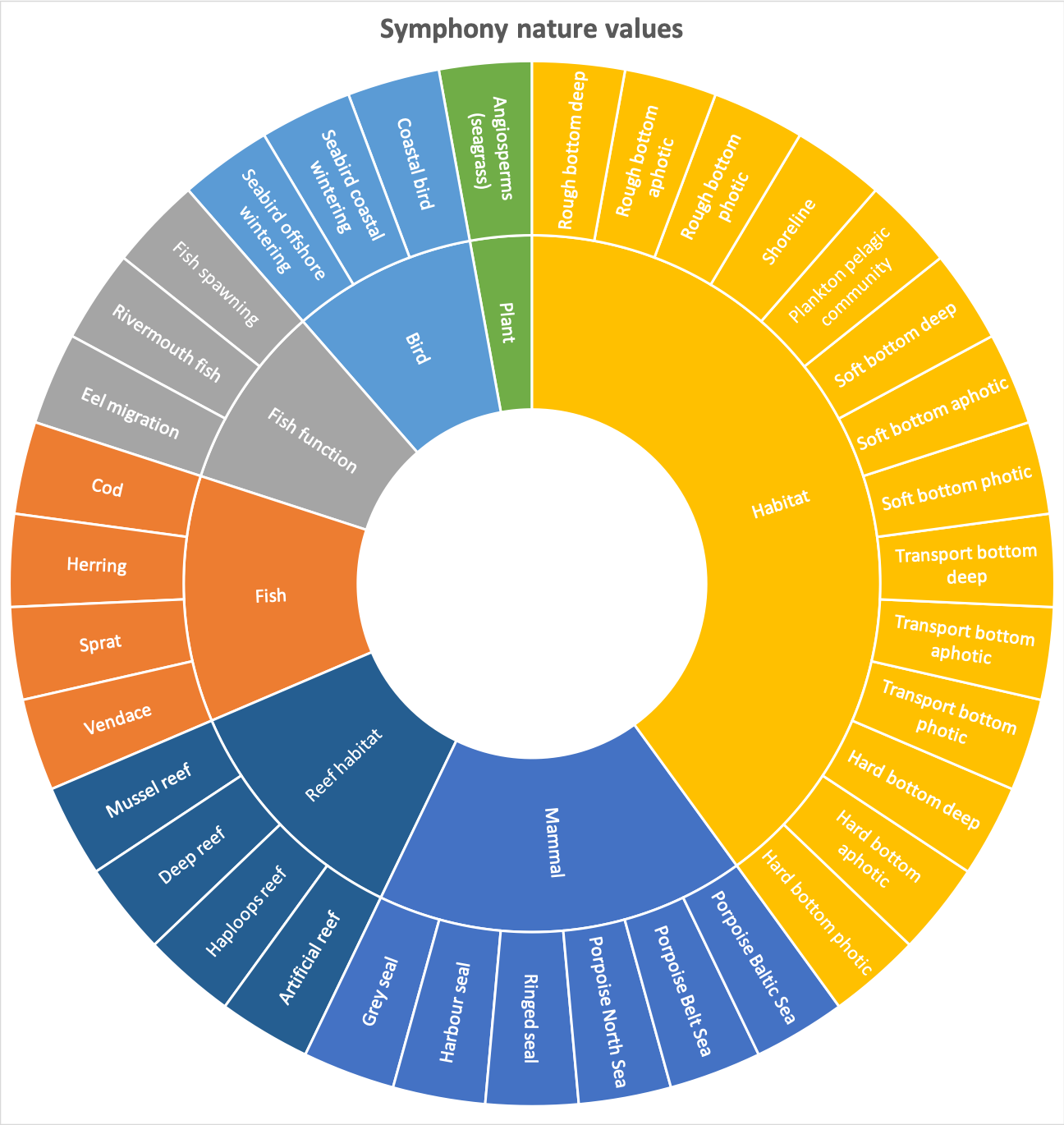
Figure 1: Symphony nature values (ecosystem components).
2. Pressures
Maps describing the spatial intensity of environmental pressures from human activities in the Swedish sea has been developed. These are also based on existing data and compiled by experts. Symphony includes 41 different environmental pressures, for example underwater noise, fish catch, and turbidity (see Figure 2).
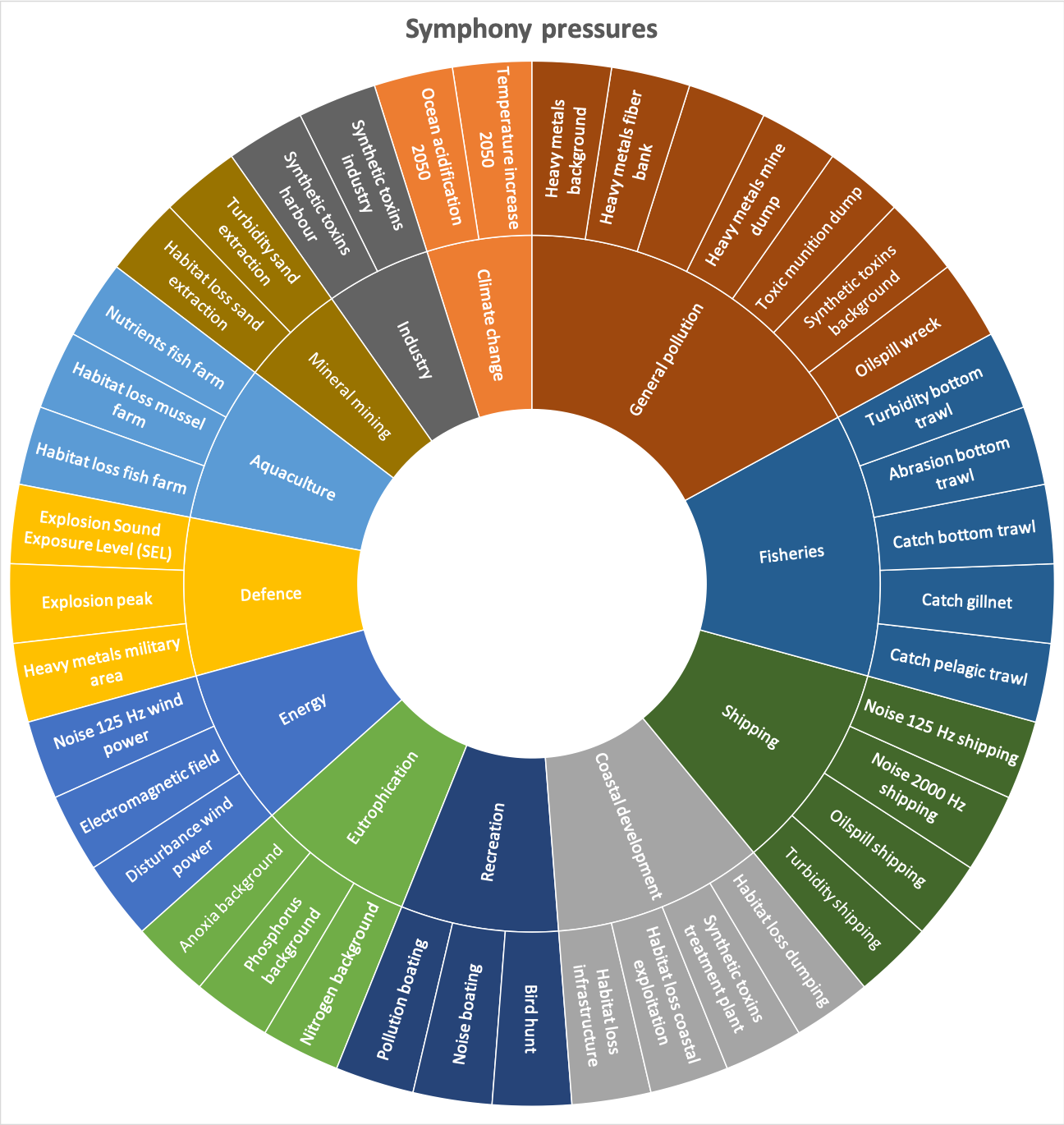
Figure 2: Symphony environmental pressures form human activities.
3. Sensitivity matrix
A matrix has been developed, describing how sensitive each ecosystem component is to each pressure. This sensitivity matrix is based on experts’ opinion from a large number of external experts. For example, turbidity has a much greater impact on fish spawning than on harbour porpoises.
4. Baseline results
The cumulative impact is calculated for every area of the sea by summing up all the impacts of all environmental pressures on all ecosystem components.
5. MSP results
The results are interpreted thrsough heat maps, showing the cumulative environmental impact and by calculating the contribution of individual sectors or activities in any area. The results are used in planning and stakeholder engagement, and the calculations are made to compare different planning alternatives and to find solutions with minimal environmental impact.
Method and development
The basic methodology behind Symphony is derived from scientific work from A Global Map of Human Impacts to Marine Ecosystems, published in the scientific journal Science in 2008. Symphony takes the application of this method a step further, by integration with ecosystem based marine spatial planning.
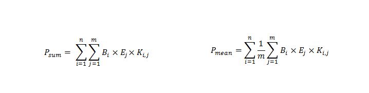
Cumulative impact (P) is calculated as the sum or mean of the product of all pressures’ (B) effect on all ecosystem components (E), given the particular sensitivity (K) of every ecosystem component to every pressure.
Symphony is based on spatial information represented in maps. Most of these maps are based on models and assumptions. This makes it very important to be aware of and communicate these limitations of method and data when interpreting the results. Symphony is not used in isolation, but as one of many planning support tools. This method is thoroughly described in the Symphony report (in Swedish). The first annex to the report, Metadata, describes all the assumptions and uncertainties inherent in each map and also discusses these shortcomings in aggregation. The Symphony compilation work has been carried out in collaboration with experts from universities, consultancies, and other governmental agencies from among others:
For quality assurance as we develop and implement Symphony, we seek guidance from experts at
- The Geological Survey of Sweden
- Chalmers University of Technology
- NIVA Denmark
- National Oceanic and Atmospheric Administration, NOAA
- University of California.
The analyses have been run in EcoImpactMapper, SeaSketch, and SyM (from Medin’s Sea and Water Consultants AB).
In the Symphony report you can find more information about the work on Symphony, with both method and results described thoroughly. The report also includes an appendix with all geodata.
If you need the report in English, please contact us. Information below.
To ensure transparency and scientific peer review, the work has been published in the scientific journal Science of the Total Environment:
Cumulative impact assessment for ecosystem-based marine spatial planning
Collaboration
Symphony has been used in a number of international collaboration projects, for example:
- NorthSEE
- Baltic LINes
- Pan Baltic Scope
- ClimeMarine
Symphony is also included in ongoing international collaboration with countries in the Western Indian Ocean through SwAM’s Program for Development Cooperation (SwAM Ocean 2019-2022).
In parallel to the development of Symphony for Swedish MSP, HELCOM applies a similar approach in their holistic assessment of the Baltic Sea (HOLAS). In addition, the basic method behind Symphony has been used for cumulative impact assessments in other parts of the world. The main difference between Symphony and most other applications is that Symphony is developed for and adapted to marine spatial planning.
The future
Symphony has proved to be a valuable tool for ecosystem based marine spatial planning. The maps of nature values and pressures will be updated and the tool will be continuously developed.


