MOSAIC – a tool to support the effective management of conservation values in marine and coastal areas.
MOSAIC is a tool to assess the conservation value of marine areas. The conservation value of an area is determined by its importance for biodiversity and ecosystem services in ecologically coherent networks.
The purpose of MOSAIC
The purpose of MOSAIC is to promote an adaptive, practical and spatially explicit ecosystem-based approach to marine nature conservation. The tool can be easily updated to include new scientific knowledge and follow ecosystem change over time (adaptive management), whilst simultaneously accounting for spatial variation and complexity – from site-specific to landscape scales.
Assessments of conservation values can be made at the landscape scale and provide a standardized framework for marine management decision making, such as which areas should be prioritized for protection, restoration or coastal and marine spatial planning. By providing a common and standardized approach MOSAIC aims to harmonize management across a range of applications.
With the help of basic GIS (geographical information systems) it is easy to overlay MOSAIC’s conservation value information onto existing maps of coastal and marine areas. MOSAIC includes information and assessments from more than 50 marine researchers and regional experts, which form the backbone of the conservation value assessments.
Expert assessments are made on more than a thousand (sometimes overlapping) marine and coastal ecosystem components (ECs), which are scored for their importance for biodiversity and ecosystem services. The expert assessments will be updated regularly to include new scientific findings. A report "MOSAIC – A tool for ecosystem based spatial management of marine conservation values – version 1" describes MOSAIC in depth and an accompanying user manual "Conservation values from a seascape perspective – User manual for MOSAIC, version 1" provides a step-by-step guide to using it.
Why is MOSAIC needed?
Effective marine spatial management requires a robust framework to identify and prioritize management actions, such as area protection, coastal/marine spatial planning and fisheries, and to achieve goals set out in directives and conventions (Figure 1). Marine spatial management is currently highly fragmented and multiple users (with differing requirements, interests and goals) are spread over many administrative areas.
A common and standardized framework is needed to find synergies and harmonize management of marine and coastal zones. A uniform method to survey marine green infrastructure will ensure the right management measures occur in the right place by providing a common evaluation method.
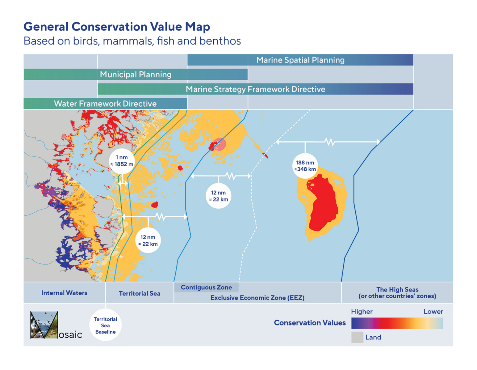
Figure 1. MOSAIC can aid spatial planning by providing information on where specific management options are best implemented (click on the picture to enlarge)
Examples of situations where MOSAIC can support management decisions whilst accounting for biodiversity and ecosystem services
What should be prioritized in marine spatial planning?
- Which ecosystem components (ECs) can be demarcated/confined and mapped for spatial management, for example how are ecosystem components that are important to fish established and delineated?
- Which ECs should be prioritized for remediation/restoration within marine environmental management?
Where should different management actions be prioritized?
- Where should a marina be located to minimize the damage to biodiversity and ecosystem services?
- Which estuaries (according to Habitats Directive Annex I and the Natura 2000 network) should be given priority for protection (Figure 2)?
How do we apply appropriate management in temporally and spatially variable environments?
- How do we account for the complexity of ecosystems in time and space so that we succeed with ecosystem-based management?
- How do we follow changes over time and effectively introduce new scientific knowledge into administrative work?
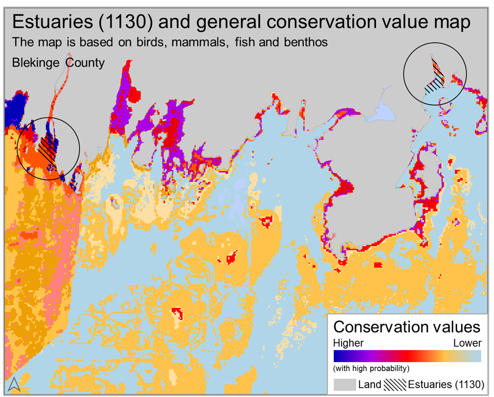
Figure 2. General conservation value map over an area of southern Sweden (Blekinge), including two estuaries (in circles, habitat type 1130). The map shows that the western estuary has a higher conservation value than eastern estuary according to the assessment framework developed in MOSAIC (click on the picture to enlarge).
How does MOSAIC work?
MOSAIC is divided into two parts (Figures 3 and 4), a preparatory part that is coordinated by the Swedish Agency for Marine and Water Management (SwAM), and an implementation part, coordinated by county administration boards or other users.
In the preparatory part a large number of experts have worked to collect and synthesize the best available knowledge to make general (non-site-specific) assessments of the conservation value of marine ecosystem components (ECs).
The general conservation values are based on criteria such as an EC:s importance for biodiversity, special importance for life-history stages, functioning of an ecosystem as a whole, threat status and different ecosystem services. These assessments are then used for landscape anlyses and site-specific assessments in MOSAIC’s implementation part. The assessments in the preparatory part focus on general patterns and not on spatial variation. This makes it easier to follow general changes over time and allows for the inclusion of new knowledge when the assessments are updated.
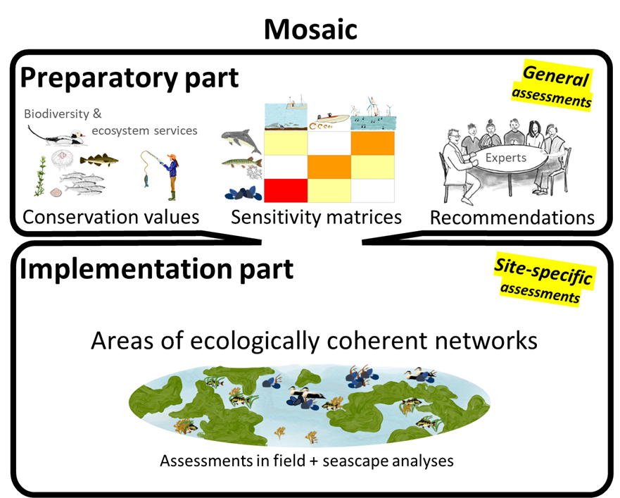
Figure 3. Overview of MOSAIC and its two parts. The preparatory part focuses on the general conservation value of ecosystem components and other information linked to these, whilst the implementation part focuses on the spatial variation of ecosystem components, and their conservation value, within a defined area (click on the picture to enlarge).
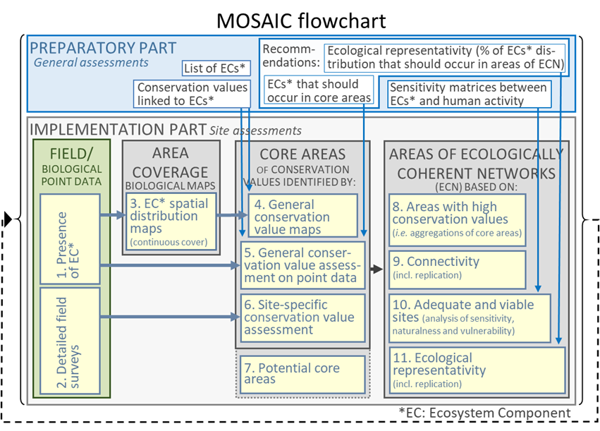
Figure 4. Flow chart showing the steps carried out in the preparatory and implementation parts of MOSAIC (click on the picture to enlarge).
In the implementation part, core areas and areas of ecologically coherent networks are identified. Core areas are areas of high conservation value with respect to biodiversity and the provision of ecosystem services.
Areas of ecologically coherent networks are areas with a high concentration of core areas in a viable and ecologically representative networks with well-functioning connectivity. Viable sites are sites where E:Cs (species and habitats) are less exposed to negative anthropogenic impacts. Ecologically representative networks are areas where the majority of the expected species and habitats are found. The implementation part focusses primarily on identifying spatial variation.
This is the first version of MOSAIC. Detailed guidelines have not yet been written for all parts of the process, but by publishing them in their current form, MOSAIC can be developed as practical experience is gained and in conjunction with parallel processes (within for example area protection and marine spatial planning).
Ecosystem components and their conservation value
The combined knowledge of more than 50 researchers and experts were used to define ecosystem components (EC:s) suitable for marine spatial management and to link conservation values to four specific sea areas (Figure 5), in accordance with guidelines in MOSAIC’s preparatory part. The assessments of conservation values have bene done for a range of EC:s in the Bothnian Bay, Bothnian Sea, Baltic Proper and Kattegat/Skagerrak, due to the differences between ecosystem and species. Establishing EC:s and their associated conservation value is crucial because it provides the basis for the succeeding steps in MOSAIC.
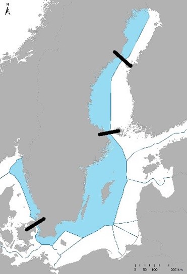
Figure 5. Conservation values are assigned to a range of ecosystem components in four sea areas (Bothnian Bay, Bothnian Sea, Baltic Proper and Kattegat/Skagerrak) in MOSAIC’s preparatory part (click on the picture to enlarge).
The list of EC:s in MOSAIC provides a logical structure to assign conservation value to marine areas and to enable better management within marine and coastal planning, area protection and fisheries as well as to achieve goals set out in national and international directives and conventions.
The EC:s in the list are also ranked in importance so that they can be used within the national marine mapping program. The structure is logical, transparent and flexible to make it usable across geographic scales and for multiple applications. The list of EC:s and their associated conservation values are currently available as Excel lists for each of the four sea areas, but access via a web platform is planned.
EC:s in MOSAIC are primarily biological, but some abiotic EC:s are included. Biological EC:s are defined, and delimited, by aspects relating to living organisms, such as populations, species, organism groups or habitats. Examples include wintering grounds for long-tailed ducks, seal haul-out areas, perch spawning areas, seagrass meadows, mussel beds and single occurrences of the charophyte (Chara horrida).
Biological EC:s are associated with higher conservation values and are sensitive to negative anthropogenic effects. Abiotic EC:s are defined, and delimited, by aspects relating to the physical environment, such as depth, bottom substrate, salinity and coastal topography. Examples of abiotic EC:s include deep areas with soft sediments, shallow areas over hard substrates and offshore sandbanks.


